Research
Project Overview
The primary focus of CGEM research activities is processing and inversion of gravity, gravity gradiometer, electrical, electromagnetic and magnetic data. While the research projects undertaken by CGEM members are formulated in cooperation with sponsors of our consortia, by research grant proposals, and by personal interests, the following partial list of research topics is presented primarily by application.

Adaptive Lp Inversion
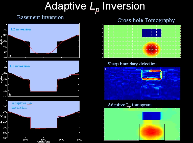
Traditional geophysical inversion methods can only recover either smooth features by applying L2 model norm in the model objective function to be minimized, or blocky features by applying L1 model norm. In reality, however, both smooth and blocky features can be present in the subsurface physical property or interfaces to be recovered.
We develop a new method to adaptively recover both smooth and blocky features in the reconstructed model from inversions of geophysical datasets. This method first detects the smoothness or blockiness of different regions of a model based on a sequence of
inversions and then adaptively applies appropriate Lp model norm with different p to complete the final inversion. We use two synthetic examples from basement inversion using gravity data and cross-hole seismic travel-time tomography to illustrate the new method.
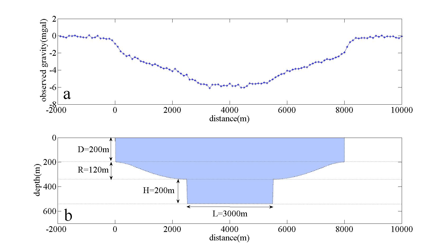
Fig 1_1 shows the synthetic faulted basement model and the simulated noisy gravity data.

Fig 1_2 shows the smoothness change at each location of the model as different threshold values are used in Ekblom norm measure which is used as the measure of length of vectors in this study because of its flexibility and differentiability. By examining which part of the model changes its smoothness most rapidly, we are able to identify the approximate locations of faults in this basement model.
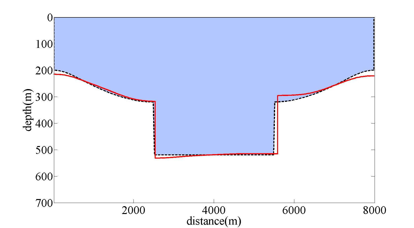
Fig 1_3 shows the reconstructed basement model by applying adaptive Lp inversion method. This model is much more interpretable than traditional L1 or L2 inversion result.
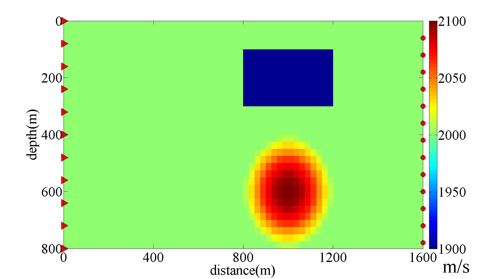
Fig 2_1 shows the synthetic cross-hole seismic survey over a 2D area that is 1600 meters long by 800 meters deep. Positions of the transmitters and receivers are marked by red triangles and circles, respectively. There are two velocity anomalies with high-velocity anomaly represented by a 2D Gaussian function and low-velocity anomaly represented by a block.
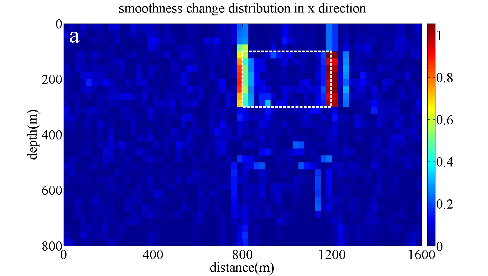
Fig 2_2 shows there exist two regions of high change in smoothness in the x direction corresponding to the vertical boundaries of the blocky anomaly.
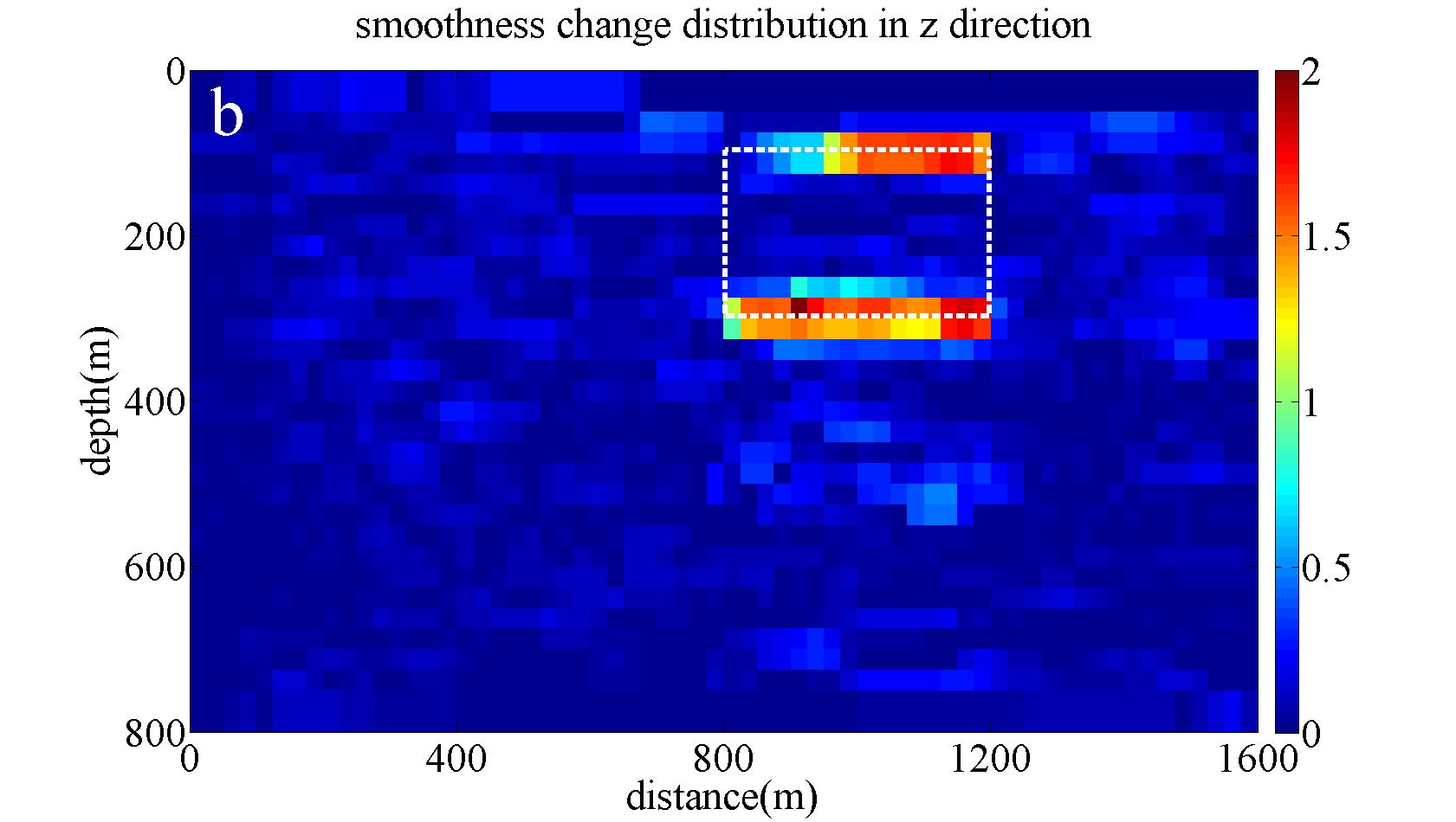
Fig 2_3 shows a similar result in the z direction and outlines the horizontal boundaries of the blocky anomaly.
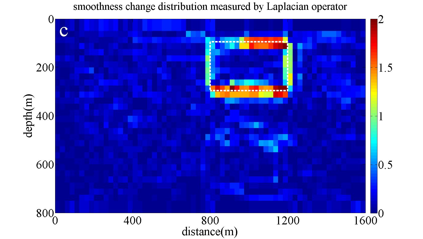
Fig 2_4 clearly indicates the overall boundary of the blocky feature by applying the Laplacian operator.
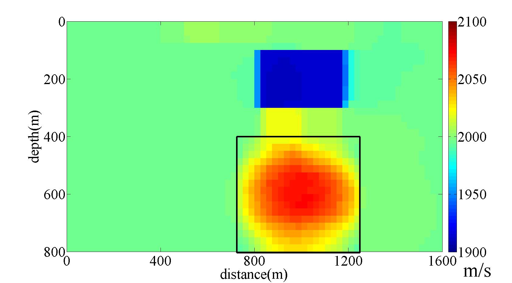
Fig 2_5 shows the recovered velocity distribution by adaptive Lp inversion.
Octree Inversions
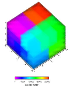
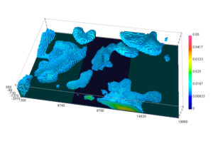 Numerous methods have been developed in order to reduce 3D inversion time or physical memory required. In general, the most computational efficiency has been achieved through integral transforms. These not only increase the speed of solving the inverse problem, but also enable larger data sets to be inverted on a computer with limited resources. The Fourier transform accelerates problems based on the convolution theorem. The separable wavelet transform has a compression property by winnowing small coefficients that do not significantly change the function after the inverse transform. These two techniques have been the principal approaches for accelerating this class of inverse problems in geophysics. We have expanded the use of the wavelet transform to an octree-based 3D inversion method to minimize the number of model parameters in the inverse solution. We incorporate 3D H ilbert space-filling curves for the ordering of parameters to increase compression capabilities.
This creates a three-step approach of octree mesh discretization, re-ordering of parameters, and finally 1D wavelet for compression of remaining coefficients. The approach enables an inversion from the mineral industry for approximately 170,000 data on a single personal computer.
Archaeology
Geophysics for mapping the Ludlow Massacre archaeology site, Colorado. Archaeological investigations at Chaco Culture National Historical Park, New Mexico.
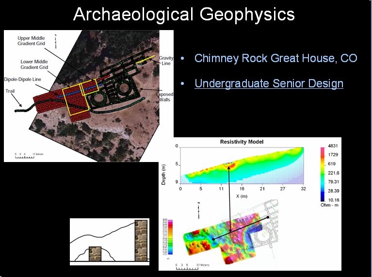
Archaeogeophysical investigations were carried out at Chaco Culture National Historical Park in New Mexico as an undergraduate Senior Design Project in 2009. The study was conducted as a part of Dr. Richard Krahenbuhl’s initial geophysical investigation within Chaco Canyon in 2006 and 2008. A group of three students collected DC resistivity, FEM, and magnetic data within Chaco Culture National Historical Park. The focus of these collections were in the plaza of one of the great houses, Chetro Ketl, in search of a buried kiva. The Court Kiva is known to be buried within the plaza region of Chetro Ketl from archaeological excavations in the early 1900’s. Following its infill and the passage of time, its location, boundary, depth and depth extent had been lost. With the three methods, the Court Kiva location was identified and estimated to have a 12 meter diameter.
Single Borehole Imaging
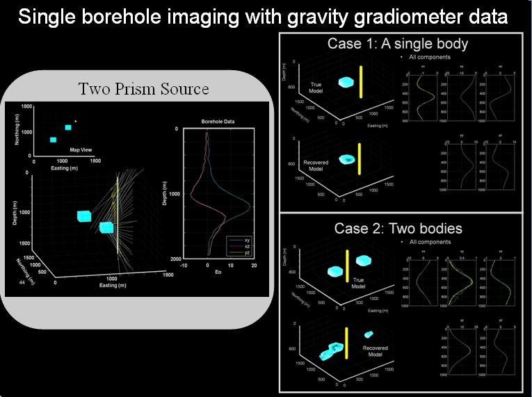
We conduct a feasibility study for interpretation of gravity gradient ssurveys in a single borehole using both an analytic and inverse-based approach. We analytically solve for distance and direction angles to a point source using the components of the gravity gradient tensor from a set of observations in a single borehole. We then generalize this approach to include the response due to a prismatic source. By inverting multiple sets of tensor components for 3D density contrast distributions, we show that as few as two independent gravity gradient components in a single borehole can be used to locate and image subsurface anomalous bodies. However, gradient measurements in a single borehole are insufficient to resolve multiple closely-spaced compact bodies.
Equivalent Source Denoising of EM Data

Emerging applications of transient electromagnetic (TEM) surveys, such as monitoring of groundwater aquifers or tracking fluid movement within petroleum reservoirs, require the acquisition of high resolution time-lapsed (4D) data sets, using three-component receivers to maximize information. However, separating signal from noise in TEM surveys can be difficult, and the magnitude of the time-lapse di erence is often on the order of the noise. We develop a method for extracting signal from noisy three-component TEM data sets collected in xed-loop, multiple-receiver surveys using a novel application of the equivalent source technique. This method takes advantage of the relationship between the three components of the observed decaying magnetic eld to improve data contaminated by uncorrelated random noise, such as that due to receiver coil misalignment and location errors. Both synthetic and eld three-component TEM data are used to demonstrate the viability of the technique. Our results suggest it is feasible to use the method in processing time-lapsed TEM data, allowing for an improved signal to noise ratio in 4D survey data.
Application of Amplitude Inversion to Gas Exploration in Volcanics

We conduct a case study on the use of magnetic amplitude inversion in imaging volcanics that are buried in sedimentary basins and have strong remanent magnetization. The application arises in exploration of natural gas hosted in volcanic units. We show that combined with reliable approaches for magnetic anomaly separation, amplitude inversion can overcome the lack of information on magnetization direction and effectively identify the volcanic units at large depths.
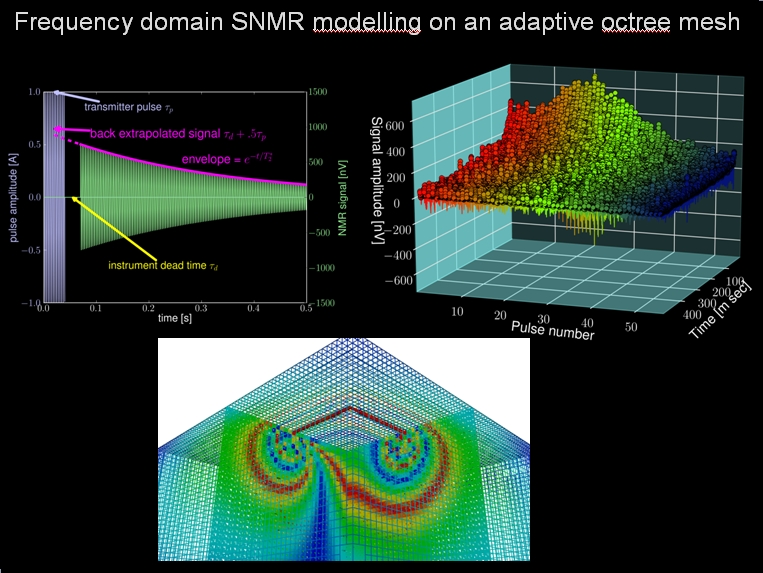
Frequency Domain SNMR Modelling on an Adaptive Octree Mesh
Inversion of Airborne Gravity Gradiometry
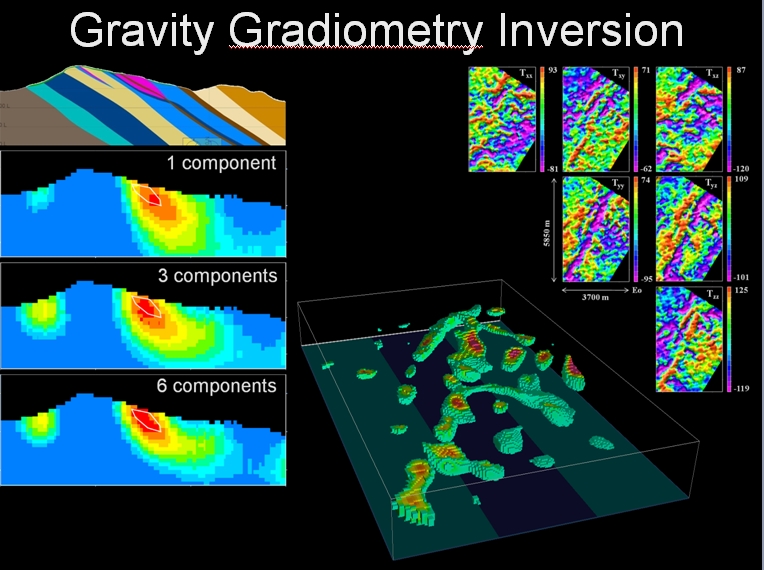
Current work has focused on applying 3D inversion to gravity gradiometry data over an iron ore target in the Quadrilátero Ferrífero Minas Gerais, Brazil. The targeted iron formation contains ore bodies that have a distinctly high density contrast which produces well defined anomalies in airborne gravity gradient data. Three density contrast models were obtained by inverting Tzz alone, Txz, Tyz, and Tzz, and finally six measured components (Txx, Txy, Txz, Tyy, Tyz, and Tzz). The commonly discussed Tzz component is sufficient to produce geologically reasonable and interpretable results. Including the two horizontal components increases the quality of the resulting model by better defining the structure and density contrast. Using all six components significantly improves the recovered density model by delineating ore geometry, dip, and distribution of high density contrast. Furthermore, an understanding of the procedure involved in inverting data for a 3D density distribution has been developed. The procedure includes a comprehension of gravity gradient processing steps, terrain correction, noise characterization, mesh design, inversion parameters, and quality of interpretation.
Geophysical Method Test Grid
Though Colorado School of Mines presents both theory and methods of geophysics, we historically have had no suitable place to teach most of our methods in a controlled area. To provide an area to test, calibrate, and teach with equipment, Andy Kass, Brett Lyons, and Armando Sosa have designed and built a test grid to encompass UXO, archaeological, utility line, and other anomalies.
The 100-by-50 meter grid has been placed in a field in Arvada, CO. The area is relatively free of electromagnetic noise with the exception of the ever-present 60 Hz interference. Fences, roads, traffic, and utilities are also at a minimum.
The table below is a partial list of the methods to be employed and the targets to be buried.
| Objects to be Buried | Methods/Instruments to be Employed |
|---|---|
| Inert UXO analogues (With varying orientation and magnetization) and scrap metal | EM-31*, EM-63*, Magnetic Gradiometry |
| Utility analogues (metallic and PVC pipe, dipping pipes, cable) | EM-31*, Magnetic Gradiometry |
| Magnetized non-metallic objects | Magnetic Gradiometry |
| Concrete block | Near Surface Seismic, GPR, DC/IP Profilings |
| Fencing materials | Ground Penetrating Radar, Magnetics, EM |
| Foundation materials | Near surface Seismic, GPR, others |
| Trench for disturbed soil | Ground Penetrating Radar |
*Instrumentation by Geonics
At present, the UXO grid, concrete block, foundation materials, and trench are complete. The deactivated rounds, which were generously donated by the Montana Army National Guard, span a wide range of artillery geometries.
We feel extremely fortunate to have access to this site. We would like to recognize and thank Mark Floyd and the City of Arvada for their help, patience, and enthusiasm. Without their committment to the research we do and Colorado School of Mines as a whole, this project would never have started.
If you have any questions or concerns about this project, please contact Andy Kass at mkass@numericalgeo.com.
Inversion of Surface and Borehole Gravity

Joint Inversions
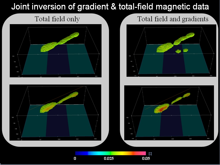
The acquisition of magnetic gradient measurements in airborne surveys has led to the improved gridding of total-field data. The approach described in this paper takes the additional information from the observed gradients one step further and directly incorporates them into 3D inversion. These data spatially constrain the recovered model of which reproduces both observed total-field and gradient datasets. In this paper, we describe the methodology to invert for a common 3D susceptibility distribution. The method is demonstrated through synthetic and field examples. The end result is more accurate recovered susceptibilities and compact anomalies compared with recovered models from total-field data alone.
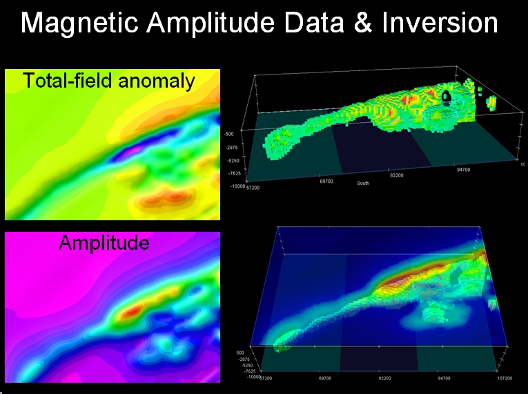
Magnetic Amplitude Data and Inversion
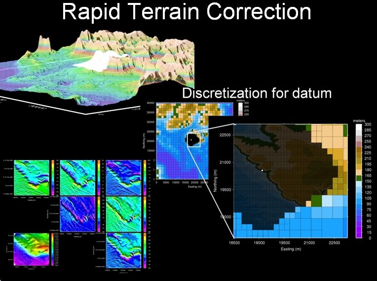
Rapid Terrain Correction
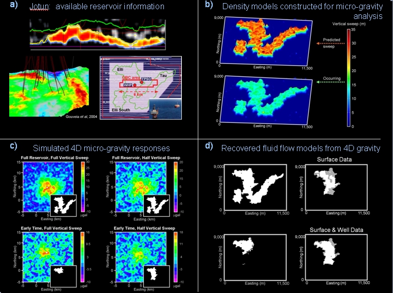
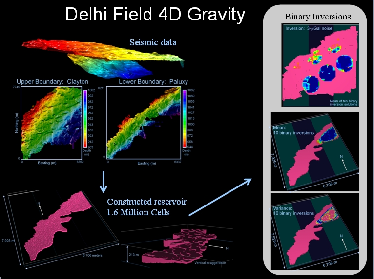
Research on 4D Gravity
Develop realistic site models for simulations
- Incorporate 3D seismic data and reservoir properties to build realistic models
- Simulations for surface and borehole data
Develop 3 different inversion techniques to better validate solutions
- Surface-based inversion
- Generalized density inversion with continuous variable
- Binary inversion
Optimal survey design parameters and model resolution analysis
- Prior to field data acquisition for cost-efficient monitoring
- Appropriate model design/discretization based on desired resolution
- Recover maximum information from field data
Feasibility studies and site applications
- Prudhoe Bay is an obvious candidate for 4D gravity monitoring
- Where else will 4D gravity prove valuable
- What depths, geometries, thicknesses, porosity/permeability/saturation limits?
Processing and Inversion
- Joint inversion of total-field and gradient magnetic data
- Lithologic inversion of multiple geophysical and geologic data sets
- Joint inversion of gravity and TEM data
- Jointly inverting surface and borehole time-lapse gravity data for enhanced oil recovery (EOR)
- Processing transient electromagnetic (TEM) data using equivalent source techniqes
- Understanding the issues for fast and accurate terrain corrections to gravity gradient data
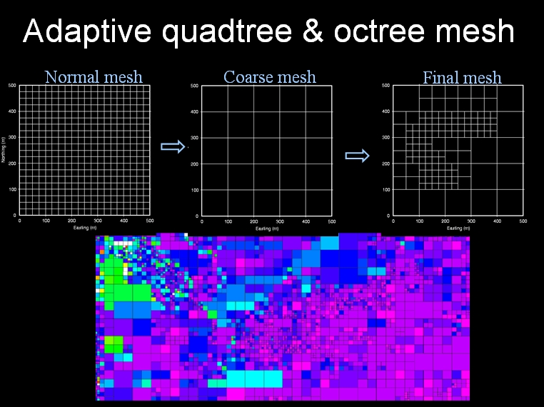
- Constructing more efficient model discretizations for faster inversions based on quadtree & octree methods
- Estimation and removal of noise in gravity gradiometer data using wavelets
- Processing of gradiometer data using equivalent sources
- Stable calculation of gravity gradiometer data
- A new formulation of minimum curvature gridding problem
- 3D inversion of gravity gradiometer data
- Binary inversion algorithm: 3D inversion of gravity data with a binary formulation
- Hybrid optimization for the binary inverse problem
- 3D Inversion of magnetic total gradient data in the presence of remanent magnetization
- Estimating magnetization direction for the remanent magnetization problem
- Remanent magnetization: 3D inversion of magnetic data in the presence of remanent magnetization
- Interpreting magnetic data that are strongly affected by self-demagnetization
- Consistent removal of regional fields in gravity gradiometry
- Misconceptions about the 3D Analytic Signal: It doesn’t exist in 3D, so stop referring to it
- Unification of Euler and Werner deconvolution in three dimensions via the generalized Hilbert transform
Stable Downward Continuation of Magnetic Data for UXO
In UXO clearance, magnetic anomalies due to multiple metallic targets may overlap at a given height above the ground surface, and the acquisition noise may significantly decrease the signal-to-noise ratio (SNR) of data. We have developed a robust algorithm for stable downward continuation (SDC) of magnetic data acquired at some height above the ground to reconstruct the magnetic data with a higher resolution at the ground surface. The algorithm formulates the downward continuation as an inverse problem using Tikhonov regularization and has the flexibility of incorporating the expected power spectrum of UXO anomalies. The degree of regularization is estimated automatically using the well-established methods in linear inverse problems. Applications show that the algorithm can reliably estimate the noise in the data and reconstruct the magnetic anomaly at ground surface within the limitation imposed by the noise. The reconstructed field at the ground surface exhibits significant enhancement compared to the original data.
Unexploded Ordnance (UXO)
- Unexploded Ordnance (UXO): Effects of magnetic soils on magnetometry in UXO discrimination problems
- Advanced UXO detection using magnetic data based on extended Euler deconvolution (in review)
- UXO discrimination using magnetic data based on shape identification through multipole moments
- Separation of geologic anomalies in UXO magnetic data through linear feature analysis
- Wavelet-based separation of UXO and geology in magnetic environments for improved detection
- Applications of Radon-Transform for improved detection of UXO in magnetic environments
- Enhancing UXO magnetic data by stable downward continuation
- Characterizing UXO remanence via a rotating coffee table with optical encoders
- Separating signal sources in UXO TEM data using principal component analysis (PCA)
- Simulating soils exhibiting viscour remanent magnetization & their EM responses
- Development of local UXO test site near Colorado School of Mines
Unexploded Ordnance (UXO) Background
- UXO is an acronym for ‘UneXploded Ordnance’
- A UXO can be defined as a munition, weapon delivery system, or ordnance item that contains explosives, propellants, and chemical agents that have not been detonated or still present a hazard when handled. They occur on or near the ground surface and can detonate when disturbed accidentally.
Types of Ordnance
- Small arms munitions
- Hand grenades
- Rockets
- Guided missiles
- Projectiles
- Mortars
- Projected grenades
- Rifle grenades
- Submunitions
- Bombs
Environmental Impact of UXO
Military munition ranges found on many military bases in the United States and in other countries are contaminated with UXO. As part of the 20th century growth of the United States military, military munitions ranges have become large in number and increasingly contaminated with UXO. The relatively recent downsizing of the military, has closed many military bases. The most costly problem of turning this land over to the public is due to UXO contamination. In addition, UXO poses a significant hazard to public safety in many parts of the world, and include armed conflicts in numerous regions throughout the globe.
Geophysical methods, especially electromagnetic induction and magnetics, have proven to be important tools in UXO clearance because of their effectiveness in detecting the presence of buried metallic objects from surveys conducted on the surface. It remains a great challenge, however, to discriminate between UXO and benign objects such as fragments and waste metals. Increased discrimination capability will reduce the false alarm rate and ultimately decrease the cost of remediation.
Defense Science Board Task Force Recommendations
The Report of the Defense Science Board Task Force on Unexploded Ordnance from November, 2003 may be downloaded here.
The report of the Defense Science Board Task Force on Unexploded Ordnance from November, 2003 states that the UXO cleanup problem is a very large-scale undertaking involving 10 million acres of land at some 1400 sites. The estimated cost of cleanup of current UXOs is tens of billions of dollars.
Two overall problems and recommendations:
- The lack of reliable data sets on past munition use at cleanup sites.
- Instruments that are used to detect buried UXO also detect scrap metal objects and other non-UXO objects, which are extremely costly to dig up.
In the role of geophysicists we consider the task force’s recommendation for problem 2. They recommend the use of more advanced technology instruments that exploit modern digital processing and advanced multi-mode sensors to achieve and improved level of discrimination of scrap from UXOs.
Useful UXO Links
- Overview of UXO https://aec.army.mil/usaec/technology/uxooverview.pdf
- US Army Environmental Center https://aec.army.mil/usaec/
- Defense Science Board Reports https://www.acq.osd.mil/dsb/reports.htm
- Most recent UXO report, 2003 https://www.acq.osd.mil/dsb/reports/uxo.pdf
- Center for Public Environmental Oversight https://www.cpeo.org/milit.html
- Information on types of munitions (pictures, description, etc) https://www.globalsecurity.org/military/systems/munitions/index.html
- UBC UXO Research Group https://www.eos.ubc.ca/research/ubcgif/uxo/index.htm
- Fort Ord Cleanup website https://www.fortordcleanup.com/
- Funding Organizations: https://www.serdp.org/ https://www.estcp.org/
- US Army Corps of Engineers UXO Site https://el.erdc.usace.army.mil/uxo
Petroleum
- Jointly inverting surface and borehole time-lapse gravity data for enhanced oil recovery (EOR)
- Joint inversion of total-field and gradient magnetic data
- Lithologic inversion of multiple geophysical and geologic data sets
- Joint inversion of gravity and TEM data
- Multi-method basement characterization for basin-scale applications
- Constructing more efficient model discretizations for faster inversions based on quadtree & octree methods
- Interpreting magnetic data in any magnetic environment (induced, remanent, self-demagnetization)
- Estimation and removal of noise in gravity gradiometer data using wavelets
- Processing of gradiometer data using equivalent sources
- Stable calculation of gravity gradiometer data
- Extended 3D Euler deconvolution
- Marine Control Source ElectroMagnetic (CSEM): Feasibility study of Marine Controlled-Source Electromagnetic surveys for detecting hydrocarbon reservoirs
- 3D inversion of gravity gradiometer data
- Reservoir monitoring using micro-gravity data
- Binary inversion of gravity data
- Hybrid optimization for the binary inverse problem
Mining
- Geophysical modeling of two willemite deposits: Vazante (Brazil) & Beltana (Australia)
- 3D Inversion of magnetic total gradient data in the presence of remanent magnetization
- Estimating magnetization direction for the remanent magnetization problem
- Interpreting magnetic data that are strongly affected by self-demagnetization
- Magnetotelluric crustal studies in Kenai, Alaska (MS thesis)
Environmental
- Monitoring CO2 injection/sequestration with multiple time-lapse geophysical methods
- Modeling 3D surface NMR data for hydro-geologic studies
- Imaging cargo containers at the nations ports for fissile material with gravity gradiometry
Geothermal
- Monitoring Enhanced Geothermal Systems (EGS) with with time-lapse geophysical methods
- Exploration for potential EGS sites and traditional geothermal systems with high-resolution airborne magnetic, gravity gradient & EM data
- Multi-method basement characterization for basin-scale applications
- Develop the ability to explore and define standard geothermal systems
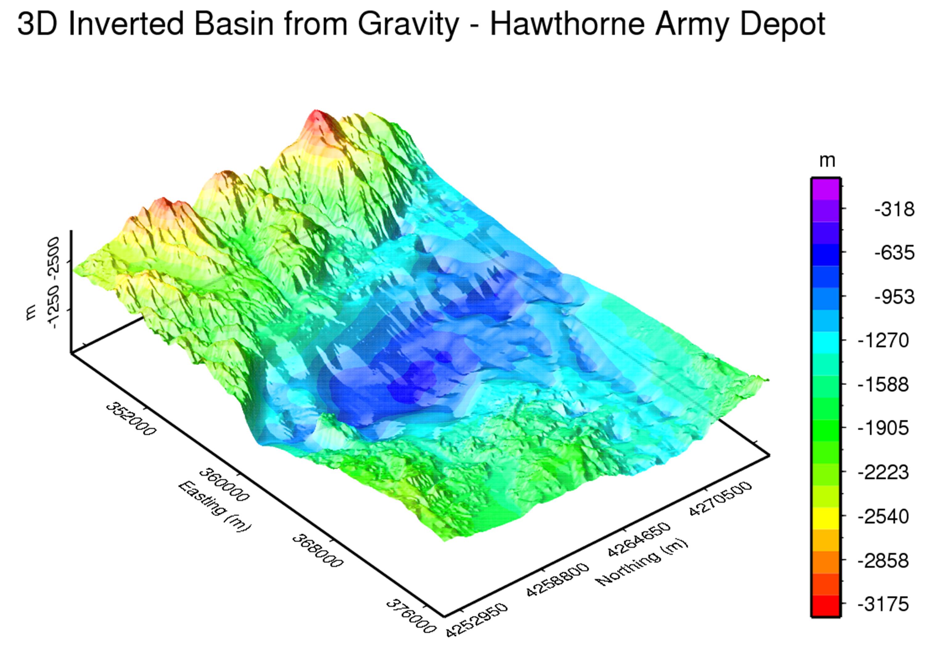
3D surface inversion result of the southern Walker Lake basin, Mineral County, Nevada. Density contrast between basin sediments and bedrock is -0.47 g/cc. Black box denotes focused are of inversion with station density of 300 meter grid, outside of black box is area of padding cells. Units are in meters.
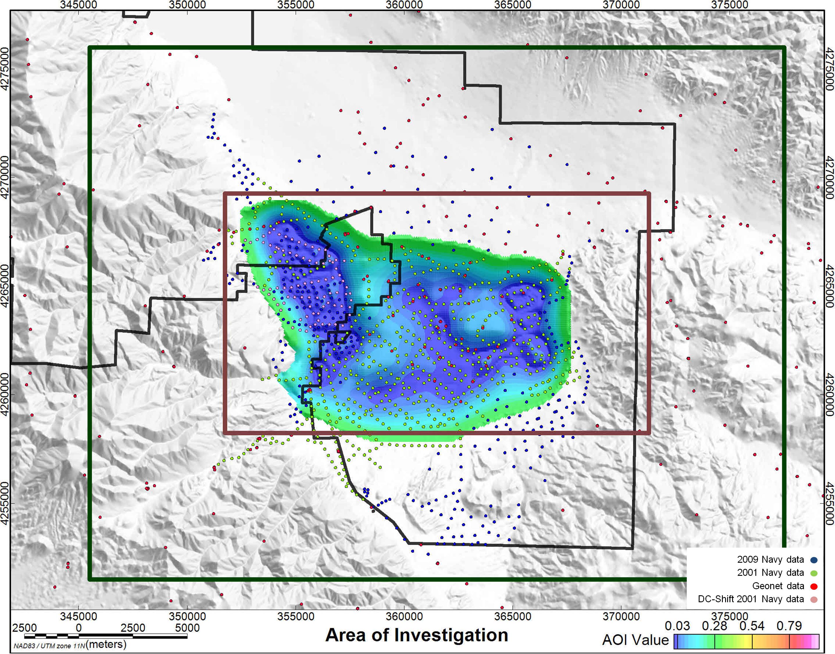
Area of Investigation. AOI shows quantitative confidence of inversion results directly related to density of gravity station locations. All values over 0.3 were removed from the image to show where high confidence of the inversion results were found. Lowest AOI values are observed where data density is 300 meters. Southern Walker Lake basin, Mineral County, Nevada.

Complete Bouguer Anomaly at 2.67 g/cc of the southern Walker Lake basin, Mineral County, Nevada.
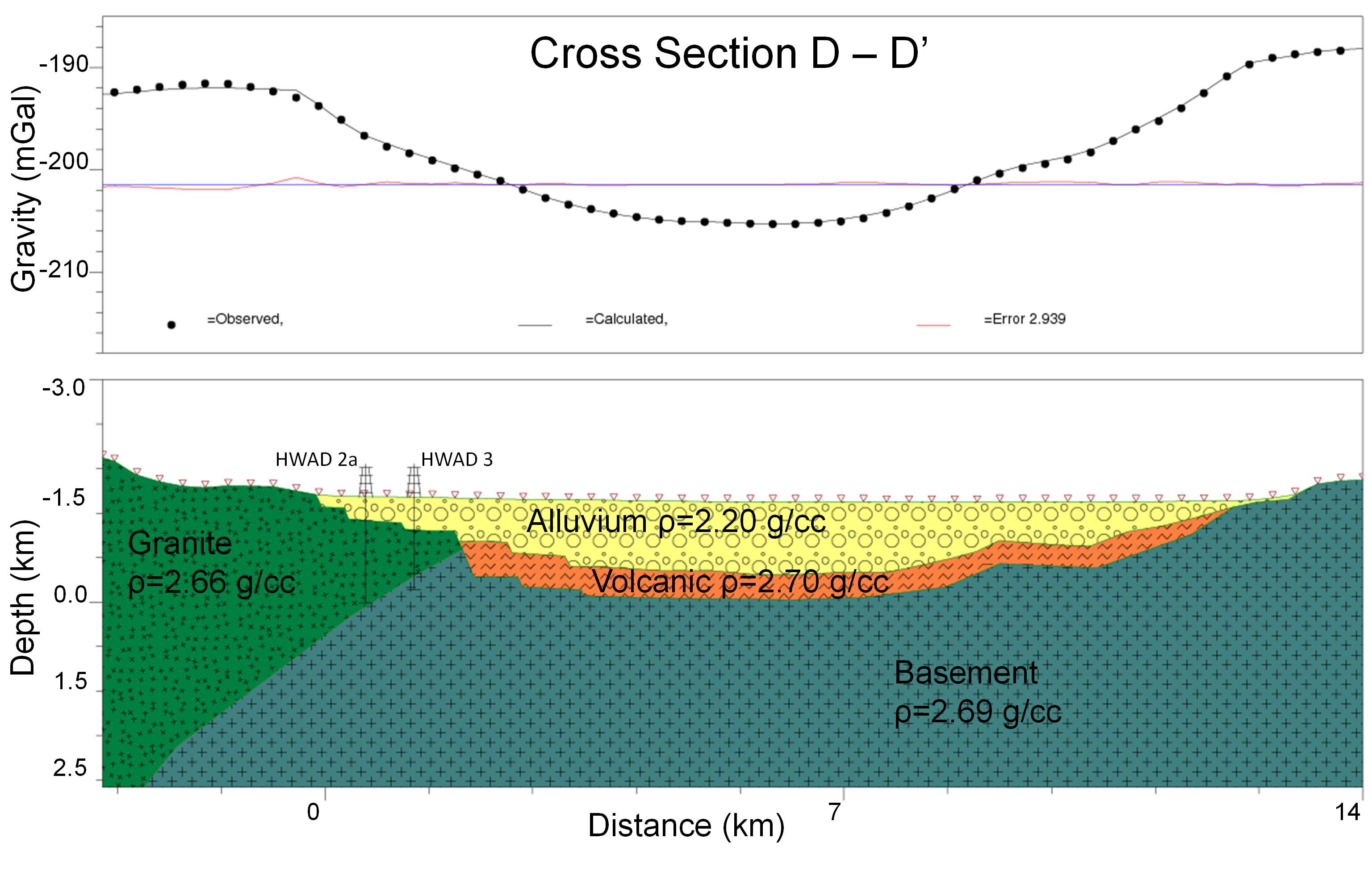
D-D’ density section of the southern Walker Lake basin. Lithologies are bound by drill hole data from HWAD 2a and HWAD 3, shown in figure.
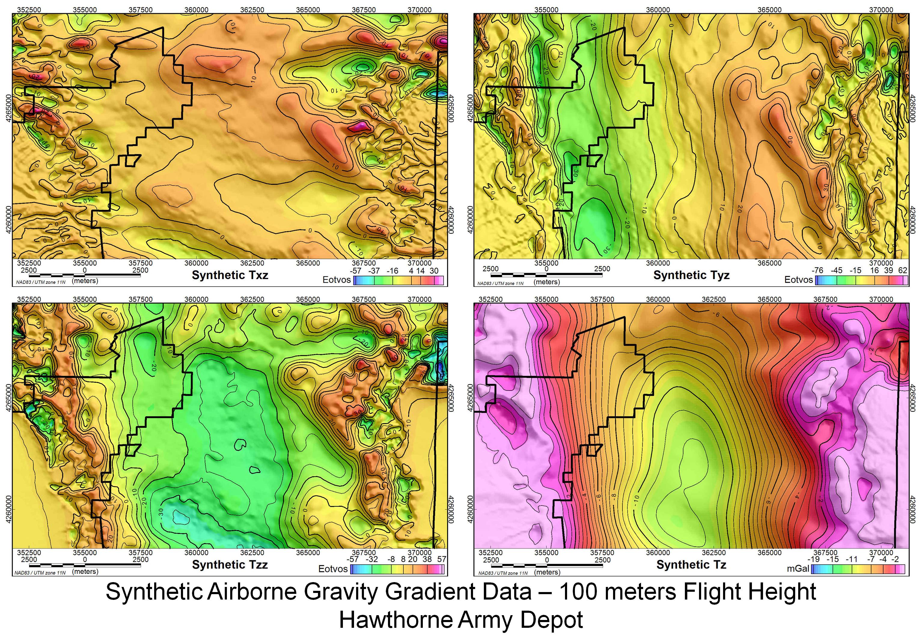
Synthetic airborne gravity gradient data at 100 meters flight height over southern Walker Lake basin, Mineral County, Nevada. (upper-left) Txz model from 3D basin. (upper-right) Tyz model from 3D basin. (lower-left) Tzz model from 3D basin. (lower-right) Tz model from 3D basin.
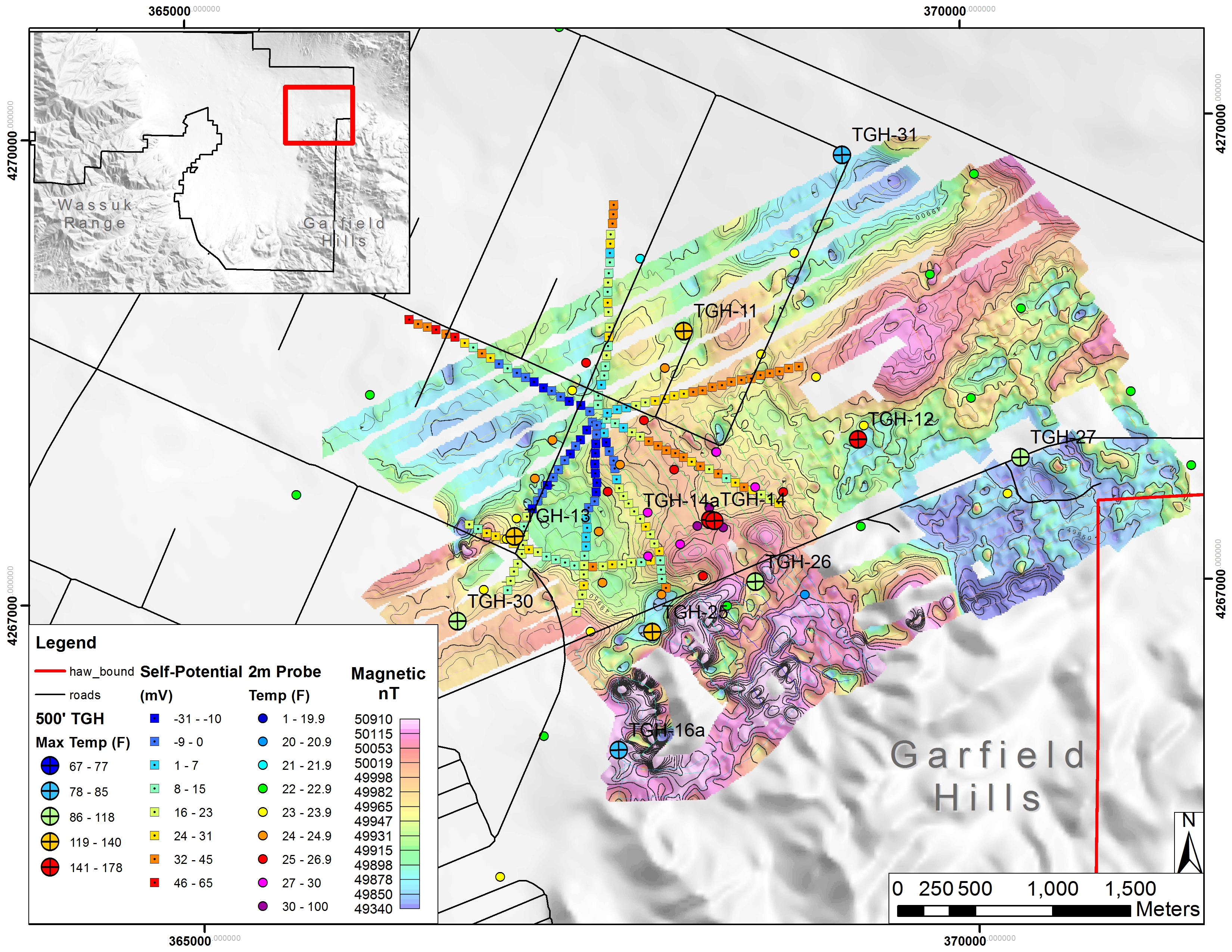
SP and magnetic data at northern Garfield Hills, Mineral County, Nevada. Data collected to locate upwelling fluids and structures associated with shallow high temperature thermal anomaly.
Hydrogeological
- Hydro-Geophysics Research (HGR): Monitoring the aquifer storage and recovery (ASR) systems using time-lapse geophysics
- Groundwater characterization in the Upper Arkansas River Valley, CO
- Time-lapse monitoring of water infiltration at Leyden Lignite Mine, CO, using gravity, CSAMT, TDEM, and DC resistivity, and induced polarization
- Multi-method basement characterization for basin-scale applications
- Modeling 3D surface NMR data for hydro-geologic studies